We have done this trip in October 2019 with a colleague after a summer school in Corsica. It is a 3 days hike in the very center of the island. In order to get there you will need a car and go to Corte, then take the D623 to the end of the Restonica Valley where you can park (6€/day). Our idea was to make a loop from the Valley to explore the surroundings, which are wonderful, see below for more details.
The maps for each day along with the corresponding elevation maps are shown below.
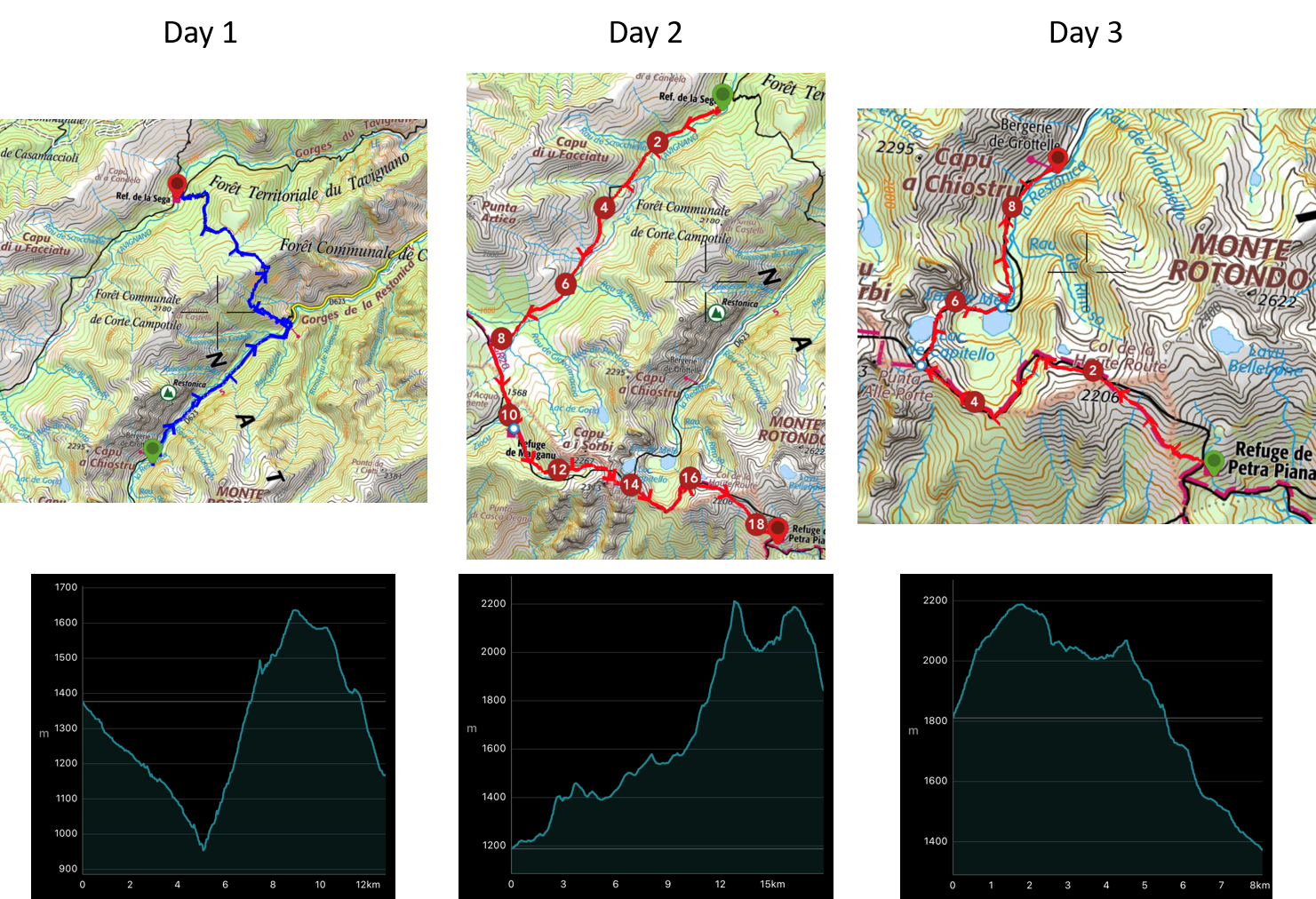
Day 1: Restonica Valley to Refuge de la Sega
We started the first day around 10:30 from the Bergerie de Grotelle. It took us 6h to arrive at Refuge de la Sega (including 1h lounch in the woods). Hike description is summarized in the table below. This first part was easy, no technical difficulty and the view is amazing throughout the hike. The refuge is very comfortable with running hot water and restrooms. The prices are fixed by the Corsica national park agency (14€/person/night inside and 7€/person/night outside in a tent). The good thing is that their is gas and camp stove available for cooking.
| Distance [km] | Total Ascent [m] | Total Descent [m] |
|---|---|---|
| 14.1 | 731 | 939 |
-
Day 2: Refuge de la Sega to Refuge de Manganu to Refuge de Pietra Piana
We started around 8:30 the second day after a gourmet breakfast (which lead to carrying much less weight on our backs!). We arrived around 11:30 at Refuge de Manganu, we had lunch there and went for Refuge de Pietra Piana where we arrived around 18:00. This day was quite hard, especially the afternoon as the terrain surface was very rough. There was a consistent need for hands in order to progress and climb up to Brèche de Sorbo and Col de Rinoso. Hike description is summarized in the table below.
| Distance [km] | Total Ascent [m] | Total Descent [m] |
|---|---|---|
| 18.6 | 1362 | 706 |
-
Day 3: Refuge de Pietra Piana to Restonica Valley
For this last day we started 9:00 and it took us 5h to finish. There is a very technical passage before coming down to Capitello Lake where you need to down-climb around 100m in a very steep slope (like 70°). I would not recommend attempting it if you are not comfortable with height or if you backpack is heavy (also if there is too much wind or if the ground is wet), each year several hikers die in this area. It is possible to turn before and directly go to Melo Lake, without any technical difficulties.
| Distance [km] | Total Ascent [m] | Total Descent [m] |
|---|---|---|
| 8.8 | 441 | 881 |
-